Enregistrez gratuitement cette image
en 800 pixels pour usage maquette
(click droit, Enregistrer l'image sous...)
|
|
Réf : T01859
Thème :
Terre vue de l'espace - Volcans (181 images)
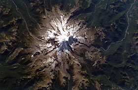
Titre : Mount Rainier, Washington, U.S.A. September 1994
Description : (La description de cette image n'existe qu'en anglais)
Mount Rainier, the highest peak in the Cascade Range at 14 410 feet (4392 meters) with its many glaciers, is the focal point of this near-vertical photograph. A massive stratovolcano with 27 named glaciers and many minor ones, Mount Rainier supports the largest glacier system in the 48 contiguous states. Visible in the photograph are deep cirques, glacier-carved valleys, and sharp ridges on the slopes of the mountain that testify to a much more extensive glaciation during the ice age. Located approximately 40 miles (64 kilometers) southeast of the Seattle-Tacoma area, the volcano has been dormant since a small explosive eruption in 1850. Mount Rainier began to form from a cinder cone nearly 1 million years ago and is estimated to have reached a height of more than 16 000 feet (4880 meters) above sea level. Geologists speculate that the former summit was destroyed about 6000 years ago by a combination of explosions, landslides, and mudflows. The largest avalanche in recent times occurred in December 1963, when a 2-square-mile (5-square-kilometer) portion of Emmons Glacier, the largest glacier on the mountain, and the upper White River Valley were covered by broken rock and chunks of ice. The surrounding mountains and lower slopes of Mount Rainier are mantled by dense coniferous forests. Mount Rainier, part of Mount Rainier National Park, is a famous ski and recreation resort.
|
|

